

These chapters (5–10) were removed from the drawing rules on 19 October 2026. They have not been reviewed and do not fully match Samgöngunet. Do not use them as rules until they have been revised.
5Editing the road network
This section covers how the road network is edited. There are several types of edit, and choosing the right one matters, because only some of them preserve history.
| Edit | When | History kept? |
|---|---|---|
| New object | A new road or node, or a road that was missing | Yes |
| Correction | The data was wrong or inaccurate; reality has not changed | No |
| Change | Reality has changed, e.g. after reconstruction | Yes |
| Closure | A road no longer exists or is no longer in use | Yes |
| Deletion | Only if the road should never have been recorded | No |
5.1New objects
New reference links or nodes are added to Samgöngunet when reality has changed or when something is found to be missing. This applies when:
- an “old” road is found to be missing, i.e. a road that has existed for a long time but was never recorded,
- a new road or road section has been built,
- a road has been reconstructed, for example:
- a new junction,
- a new roundabout,
- a single carriageway converted to a dual carriageway,
- a median barrier installed, creating a 2+1 road,
- a road has been improved in a way that changes its alignment,
- an incorrect generalization needs correcting and missing parts need adding.
When a single carriageway is converted to two, or a median barrier is installed, the centreline of one carriageway sometimes does not move. A new reference link is then not needed for it, but it must be possible to choose a view date both before and after the change and see how the road looked at each point in time.
5.2Correction
A reference link is corrected for one of two reasons:
- It contains errors, for example incorrect feature values.
- The data needs improving, for example to make the geometry more accurate.
A correction is final, and the previous state cannot be recovered afterwards. A correction leaves no “before and after” history.
5.2.1Correcting geometry
A reference link has a topology, i.e. information on which nodes it connects to, and a geometry that describes its shape and determines its length.
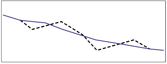
- Minor errors of a few metres do not need to be corrected at all costs.
- The geometry can be corrected on part of the link or the whole link.
5.3Change
When reality changes, Samgöngunet must change too. Unlike a correction, a change preserves history, so both the state before and the state after the change are stored in the database.
Examples of changes:
- A crossroads is rebuilt as a roundabout.
- A single carriageway is converted to a dual carriageway.
- A new road is built and connected to an existing road.
In each example, the state before and after the change can be seen by choosing different view dates.
5.4Closure
When a road no longer exists or is no longer in use, it is closed in Samgöngunet. A closure is in fact a change, made by setting an end date. With a view date before the closure the road appears as it was; after the end date it is no longer shown. A closure therefore preserves history.
What is closed are parts of reference links or whole reference links. In practice it is always parts of a link that are closed. When all parts of a link are closed, the link itself counts as closed.
When a road with a road number is closed, the “road number” feature must also be closed. The road number is a continuous feature, except on access roads that do not connect to a national road. Such access roads should not have a road number.
When correcting geometry, do not close the old link and draw a new, more accurate one alongside it. Nobody viewing a corrected road wants to see the old, wrong geometry for an earlier date. Use a correction, not a closure.
5.5Deletion
Deletion means that the reference link disappears from Samgöngunet and cannot be viewed historically either. Deletion must therefore be used with the utmost caution and always in consultation with the Samgöngunet administrators. As a rule, roads should be closed instead. Deletion is in effect a correction and leaves no history.
A reference link may only be deleted if it is clear that it should never have existed, for example a road section recorded by mistake that has never existed in reality.
What can technically be deleted:
- reference links (whole links only),
- nodes not connected to any reference links.
5.6Direction
Reference links have a direction, but there is no requirement to record them in a particular direction. Preferably:
- the direction follows the direction of travel where one is given, for example on slip roads. On dead-end roads the direction runs from the junction to the end of the road,
- otherwise, the direction follows the road number or street name,
- if neither applies, the direction runs from south to north and from west to east.
Never reverse the direction of an existing reference link.
5.7Consultation between road authorities where networks meet
Road authorities must always consult each other when a change to one authority's network affects another's, for example when a node where the networks connect is affected, or when the extent of a feature crosses a municipal boundary. The consultation should be documented when data is delivered to Samgöngunet.
6Editing features
Detailed descriptions of features, their structure, quality requirements, data collection rules and permitted values can be found in the Samgöngunet feature catalogue; see section 10.
The same types of edit apply to features as to the road network:
6.1New features
A new feature is recorded when reality has changed, for example when a new surface has been laid or a new speed limit has come into force.
6.2Correction
A feature is corrected when it is wrong, for example when one or more of its values are incorrect. A correction leaves no history: it is not possible to see one value on one date and another on a different date.
6.3Change
When reality changes, the feature must change too. The previous value is then stored, so a change preserves history.
6.4Closure
When a feature no longer applies, it is closed by setting an end date. With a view date before the closure the feature appears as it was; after the end date it is no longer shown. A closure therefore preserves history.
6.5Deletion
Deletion means that the feature disappears completely and cannot be viewed historically either. Deletion must therefore be used with the utmost caution and always in consultation with the Samgöngunet administrators. Features should be closed rather than deleted. A feature may only be deleted when it is obvious that it never applied. Deletion is in effect a correction and leaves no history.
7History
Historical data makes it possible to view the road network as it was at any point in time, together with the features that applied then. It is used, among other things, to study:
- trends in traffic,
- accident rates before and after changes to the road network or traffic rules, or changes over time in a given area,
- the extent of the road network and its features at different points in time.
All data in Samgöngunet has a time dimension. Each part of a reference link has a start date, the day the road section opens to traffic (valid from and including that date), and an end date, the day it is taken out of use. Between those dates the section is valid, i.e. open to traffic. Taking a section out of use by setting an end date is called closing it.
Historical data is data that used to be valid but no longer is. It stays in the database with an end date in the past and is shown if an earlier view date is chosen. The same mechanism is used to record roads and features that have not opened yet, i.e. with a start date in the future.
Do not set a start date far back in time, as many later versions may then need adjusting. The rule of thumb is to go no more than one year back. When delivering features older than one year, use a fictitious date (see 7.1) unless otherwise agreed.
7.1Unknown start date
If the exact date is not known, a fictitious date may be used: 1 January or 1 July, depending on the half-year in which the record was made. A date must always be given.
7.2Updating after a reconstruction
- Draw and connect new reference links for the road network created by the reconstruction.
- Close the parts of the road network that are no longer valid. Use the date of the reconstruction as the start and end date, not the date of recording.
- Both geometry and topology must be correct, so that the network can be seen as it was before and after the change.
- Do not drag existing reference links and nodes around to “make it fit”. There is a high risk of destroying the history if you do.
- Look after the history! Before correcting, changing or adding anything, look at the network at that location both backwards and forwards in time, if your tool supports viewing the network historically. This gives you the full picture of what has happened and helps you avoid errors that are otherwise easy to make.
All feature types should be available when the road network is edited, because changes to the network often require features to be added.
7.3The network exists in many time versions
When the road network is changed or corrected, old connections are often left “hanging”, i.e. without a connection to the changed road. This must be fixed! Make sure all adjoining roads are connected. Conversely, roads that are no longer connected must be closed over the relevant stretch.
7.4Correcting an incorrect generalization
Avoid redoing a generalization unless it is strictly necessary or the result of a reconstruction. Such edits often cause problems, especially with how features are attached to the road. If it must be done anyway, use a correction where possible. If a correction would cause major problems, a change (draw new and close the old) may be used instead. Remember to record features on the new reference links.
8Worked examples
Below are examples of common situations when updating the road network.
8.1Improving the geometry of a reference link
- Situation
- The geometry of a reference link needs improving.
- Edit
- Correction.
- Solution
- The geometry of the link is corrected in one of the following ways:
- the link is moved in the horizontal plane to the correct position, or
- it is replaced with new geometry from a geometry file.
- Keep in mind
-
- Do not close the link; keep using it with the new geometry.
- Minor errors of a few metres do not necessarily need correcting.
- Part of the link or the whole link may be corrected.
8.2Staggered crossroads
- Situation
- Two cases:
- Edit
- Start by deciding whether the update is a correction or a change; see below.
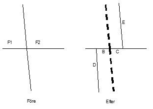
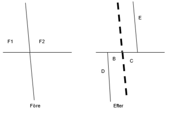
Change. If the junction has been rebuilt and now looks different from its representation in Samgöngunet, the previous representation must be kept as history. The affected parts of the reference links are closed and new links are drawn where needed.
Correction. If the junction turns out to be drawn incorrectly and should never have looked like that, it is corrected. This only works if the line being changed consists of two reference links meeting at the junction. If a single link runs through the junction, a correction is not possible; parts of it must be closed and new links drawn, i.e. a change.
The correction consists of adjusting the geometry of the link running through the junction (north–south in the figures):
8.2.1From ordinary to staggered crossroads
- Move the existing node to one of the two new positions. Choose carefully, as it may matter if the node carries features such as turn restrictions.
- Add a new node at the other connection point.
- Adjust the vertices of the link over a sufficiently long stretch up to the connection points from both directions (north and south in the figure).
- Features with a short extent near the junction will probably need adjusting, as will features that start or end at the node that was moved.
8.2.2From staggered to ordinary crossroads
- Move one of the two nodes to the new position. Choose carefully, as it may matter if the node carries features such as turn restrictions.
- Adjust the vertices of the link over a sufficiently long stretch up to the connection point from both directions (north and south in the figure).
8.3Change to a road section
- Situation
- A road section has been changed, for example realigned, given grade-separated junctions or roundabouts, fitted with a median barrier, or converted to a dual carriageway.
- Requirement
- History must be preserved, i.e. it must be possible to see the road network and its features both before and after the change.
- Example
- A road has been reconstructed and a bend straightened out. The figures show the road before and after. Both states are preserved in Samgöngunet.
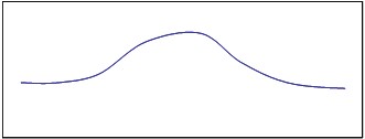
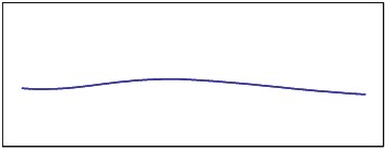
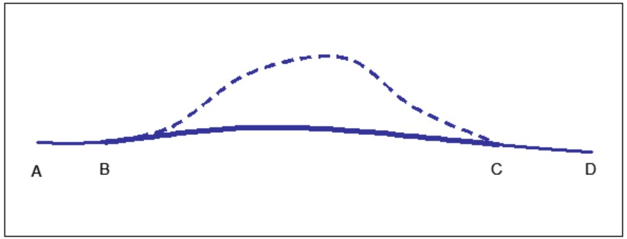
- A–B is part of the original link.
- B–C (dashed) is the closed part of the original link.
- C–D is part of the original link.
- B–C (bold) is the new reference link.
The new link must not start at A and run all the way to D. The original link must remain and keep working on the stretches A–B and C–D as before.
Solution:
- Draw the reference links of the new section.
- Connect the new section to the existing road at both ends.
- Close the part of the old road that is no longer in use (the dashed line).
8.3.1Example: new roundabout
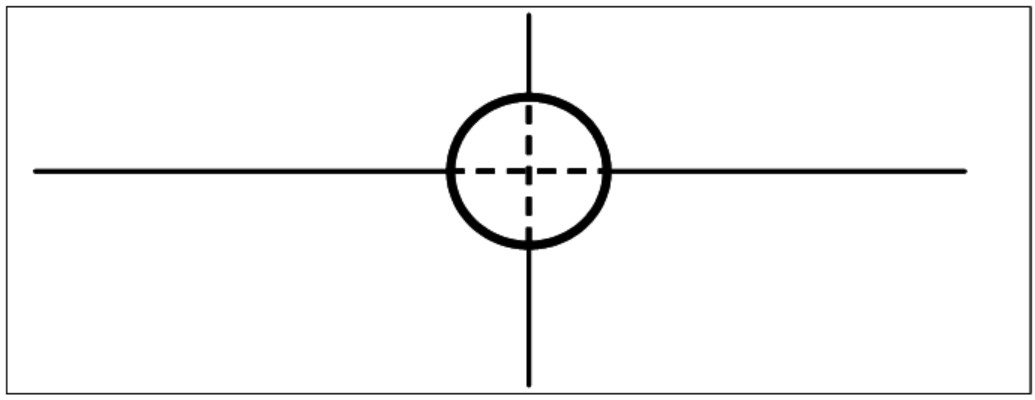
Draw the reference links of the roundabout (the circle in the figure) and connect them to the existing road. Close the parts of the old road that are no longer in use, i.e. those that ran through the new roundabout (the dashed lines).
8.3.2Example: median barrier installed
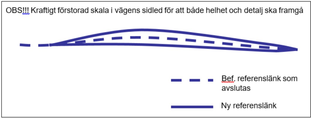
8.3.3Example: conversion to dual carriageway
If the existing carriageway stays where it is, its reference links are kept and new links are drawn for the new carriageway. Often, however, the line has to move, and new links must then be drawn in both directions; otherwise the history becomes misleading. In major reconstructions where two new carriageways are built, the old link is closed and new links are drawn for both carriageways.
8.3.4General notes on changes
Record on the new sections the features that must accompany the road network. Some can be taken from the old section, but many have to be collected again. All features for which the data supplier is responsible must be delivered.
The edit is a change. Existing reference links in Samgöngunet must not be corrected; they stay where they are and are closed on the affected stretches. If this is not followed, the historical data is destroyed.
8.4Junction between a national road and a municipal road
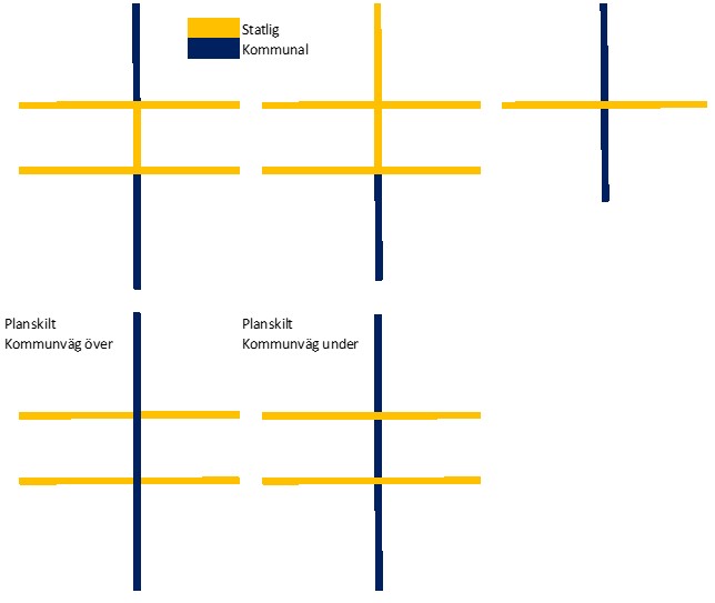
Take a junction between a national road with two carriageways and a municipal road with one carriageway. Figure 9 shows examples of who is the road authority in such junctions.
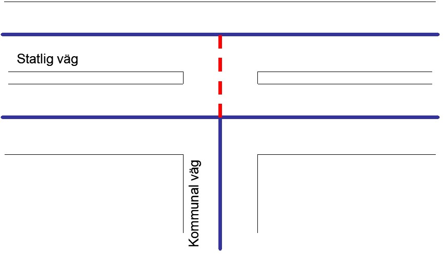
If the short link between the carriageways (red dashed line in Figure 10) is entirely missing from Samgöngunet and the municipality does not add it, Vegagerðin should add it.
8.4.1Features on the short link
The following rules set out who delivers features for the short link between the carriageways.
| Feature | Who delivers, and how |
|---|---|
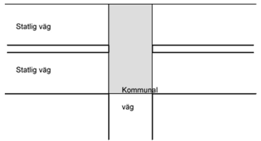
| Road authority | Vegagerðin is normally the road authority for the national road, although a municipality may be the road authority for some sections in urban areas. A road authority is responsible for areas rather than individual links. It is common for the authority responsible for both carriageways to also be responsible for the shaded area in Figure 11. If Vegagerðin is the road authority for the larger road, it is therefore reasonable for it to mark the short link with road authority = Vegagerðin, even though the link is really part of the municipal road. The reason is that if the link is very short, the area it crosses is probably part of the larger road. |
| Road number | The link gets road authority = Vegagerðin and the same road number as the national road, so that it becomes a branch of it. |
| Street name and other road names | If the municipal road has a street name, the municipality decides whether the short link is part of the street name or whether the name starts at the next link. If the municipal road continues on the other side, the street name should be continuous through the junction. The same applies to other road names. |
| Surface and road width | Delivered by the road authority for the link. If the link is very short, the road it represents is to some extent fictitious. If the width is unknown, the width of the adjoining road may be used. |
| Functional road class | Delivered by the road authority for the link. It normally gets the same class as the municipal road, but if it is a branch of a national road, a class one step lower than the national road may be chosen. |
| Traffic regulations | Delivered by the body that decides the regulation, through Samgöngustofa (the Icelandic Transport Authority). They are therefore independent of who the road authority is. If traffic regulations are missing for the link, this should be reported to Samgöngustofa. |
8.5Roundabout between a national road and a municipal road
Roundabouts where a national road and a municipal road meet can also raise boundary questions.
Delivering the road network. If the municipality has good data for the location, it delivers the geometry of both roads, including the roundabout. Consultation with Vegagerðin must still take place as usual. If design drawings exist, whoever holds them delivers the geometry.
Delivering features. First establish who the road authority for the roundabout is, usually Vegagerðin or the municipality.
| Feature | Who delivers |
|---|---|
| Road authority | The road authority for the roundabout. |
| Road number | Always Vegagerðin. Note that some links in the roundabout are part of the road number's extent. |
| Functional road class | The road authority for the roundabout. |
| Street name and other road names | The municipality. If a municipal road starts or ends at the roundabout, the municipality decides whether the roundabout links are part of the street name. The same applies to other road names. |
| Surface and road width | The road authority. |
| Traffic regulations | The body that decides the regulation, through Samgöngustofa. Independent of who the road authority is. |
8.6Staggered crossroads and similar cases
When a crossroads is rebuilt or generalized from or to a staggered crossroads (small shifts of about 10 metres), all features that are, or should be, on the short intermediate link must be updated so that their extent is correct. This applies to features that may change because of the junction layout, such as road number, street name and road width; see the tables below. The same problem can arise in other road network edits. If the actual situation is hard to establish, the update is made schematically as follows.
8.6.1From staggered to ordinary crossroads
Review the features on link A in Figure 12:
- The road number must be corrected (only Vegagerðin can change road numbers). This applies both to the road that was unchanged and to the road that was staggered.
- The features in the table are handled according to the rule in it.
| Feature | Rule |
|---|---|
| Road authority | Feature F1 is also applied to section B, and feature F2 to section C. |
| Recommended route for dangerous goods | |
| Functional road class | |
| Street name and other road names |
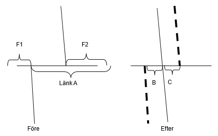
8.6.2From ordinary to staggered crossroads
Review the features to be placed on sections B and C in Figure 13:
| Feature | Rule |
|---|---|
| Road authority | If F1 and F2 are the same, the same road authority is applied to B and C. Otherwise, adjust the road authority of F1 and F2 so that each applies from the junction. |
| Road number | The road number must be adjusted (only Vegagerðin can change road numbers). This applies both to the unchanged road and to the road that is now staggered. |
| Functional road class | Check the class of every section in the junction. If B and C connect the two roads with the highest class, B and C get that class. If B and C lie outside the highest-class sections, choose the highest of the lower classes. |
| Street name and other road names | If unclear, ask the road authority to decide. |
8.7Reconnecting adjoining roads after reconstruction
- Situation
- A road section has been changed, for example realigned, given grade-separated junctions or roundabouts, fitted with a median barrier, or converted to a dual carriageway. After the change in Samgöngunet, adjoining roads may be left hanging, i.e. not connected.
- Requirement
- The adjoining roads must be connected; otherwise the network cannot be used for routing, for example.
- Solution
- Obtain the data needed to edit the adjoining roads as well. The basic rule is that whoever carried out the reconstruction (usually Vegagerðin or a municipality) and holds the design drawings also records the change in Samgöngunet.
- Edit the adjoining roads and make sure they are connected.
- Record on the new sections the features that must not be missing. Some can be taken from the old section, but many have to be collected again. All features for which the data supplier is responsible must be delivered.
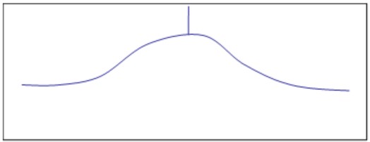
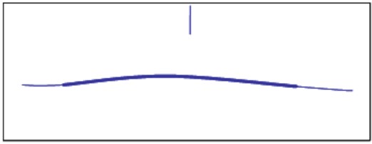
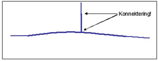
Do not correct (drag) the old adjoining road onto the new road, as this destroys the history.
Rules:
- If a reconstruction is the cause, the adjoining road is handled as a change: close parts of it if it has also been rebuilt, and draw new links as needed to connect it.
- Do not make a correction, as it destroys the history.
- Use the tools in your editing software to verify that the adjoining roads are actually connected.
- Exception: if the shift is less than 2.5 metres, it may be made as a correction, with the adjoining road following along.
9Data origin
The origin of every reference link must be recorded, i.e. how the data was captured and how it was processed. This is done by linking each reference link to an origin feature, reference link origin. The same origin feature can be linked to many reference links, which then share the same origin. The origin is described partly by the method used to create the link.
The main purpose is to make the data traceable, so that its source can be identified if discrepancies are found.
More information is available in the Samgöngunet feature catalogue; see section 10.
10Related documents
- Samgöngunet feature catalogue, version 1.2 (2024) (in Icelandic): description of features, values and quality requirements.
- Teiknireglur á íslensku